Unspecified (2011) Arctic Ice-edge Map. [Image]
![[img]](http://library.arcticportal.org/1493/1/Braedslumark_iss_source_AP.jpg)
|
Image (JPEG)
Download (4MB) | Preview |
Official URL: http://www.arcticportal.org
Abstract
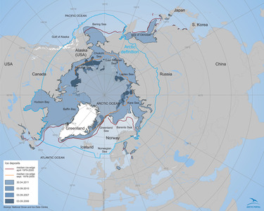
The maps shows the median ice-edge in the Arctic in april and september from 1979 to 2000. It also displays the ice deposit in 2006. 2007, 2010 and 2011. The data source is National Snow and Ice Data Centre.
| Item Type: | Image |
|---|---|
| Related URLs: | |
| Subjects: | Research and Education > Maps |
| Organizations: | Unspecified |
| Date Deposited: | 17 Oct 2011 09:53 |
| URI: | http://library.arcticportal.org/id/eprint/1493 |
Actions (login required)
 |
View Item |